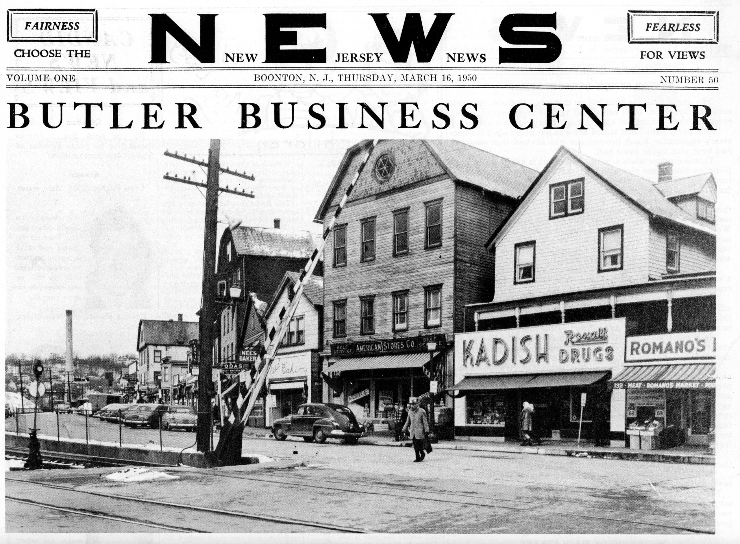
Here are two views of the stores and merchants populating Main Street in Butler NJ, on a fine Spring day in March 1950. At that time it was a quiet factory town – the devastating fire that would destroy the borough’s largest employer, the Pequanoc Rubber Company, was still seven years into the future.
There’s a lot to examine in these two photos. In the first, taken from Park Place, shows the hulking three-story American Stores Company (Acme) next to Kadish Drugs. The much-beloved Nees Bakery (and other stores) are remembered to this day.
By clicking on the photo, you’ll open a new tab with the full-sized image.
If you chose to stroll up the street, you’d pass Romano’s Market, the Acme, and Kadish Drug Store. You might be tempted by the mouth-watering odors wafting from the open door of Nees Bakery. Further up, you’d pass Louis Levine’s fine furniture store, the Butler News Company, and a variety of others. At F.B. Whittle’s Hardware, you could pick up just about anything you’d need for around the home or garden. Across the street, you might see a train pulling into the Butler depot. Beyond Tintle and DePuyt Taxi Service, a ways up, you’d see the Pequanoc Soft Rubber Mill with its 225-foot smokestack. Just past Harry and Joe’s Cut Rate Meat Market, you could, if you wished, get a room at F.R. Casterlin’s Park Hotel and Stables – at one time it was known from one end of the East to the other – or just have a meal at their well-stocked bar & grill. Truly, uptown had just about anything you might need.
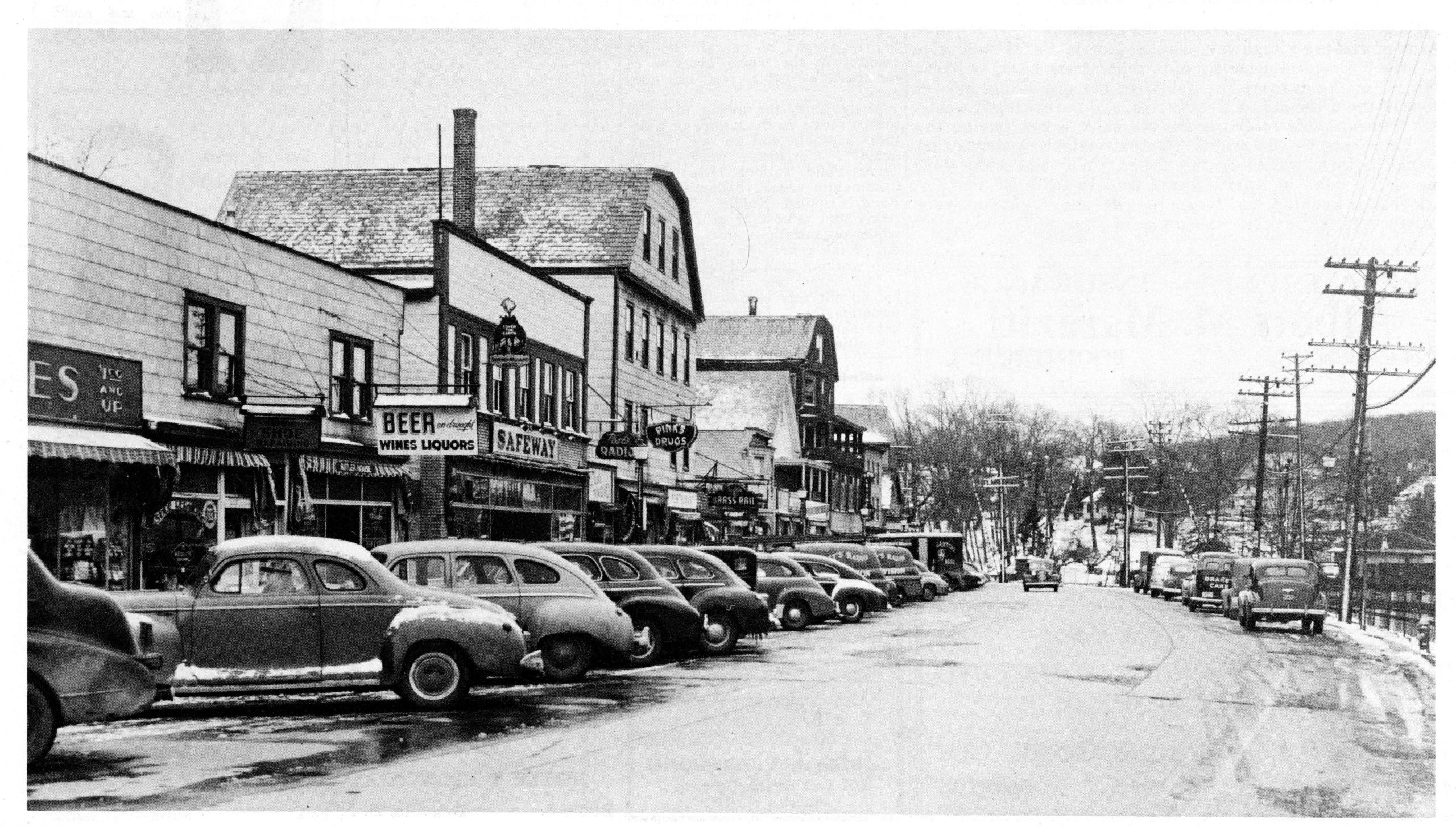
But wait – you haven’t seen what’s down Main Street the other way yet.
By clicking on the photo, you’ll open a new tab with the full-sized image.
At extreme left there appears to be a variety store (“$1.00 and up”). This side of the liquor store and Butler House (rooms to let) you could get your shoes repaired. After the Safeway is Claude Post’s radio and television sales and repair shop. (Those things were heavy, so he would send a repairman to take it back to the shop.) You’d stroll past Tice Hardware, Pink’s drug store, the Brass Rail (where you might wet your whistle with a beer), and more.
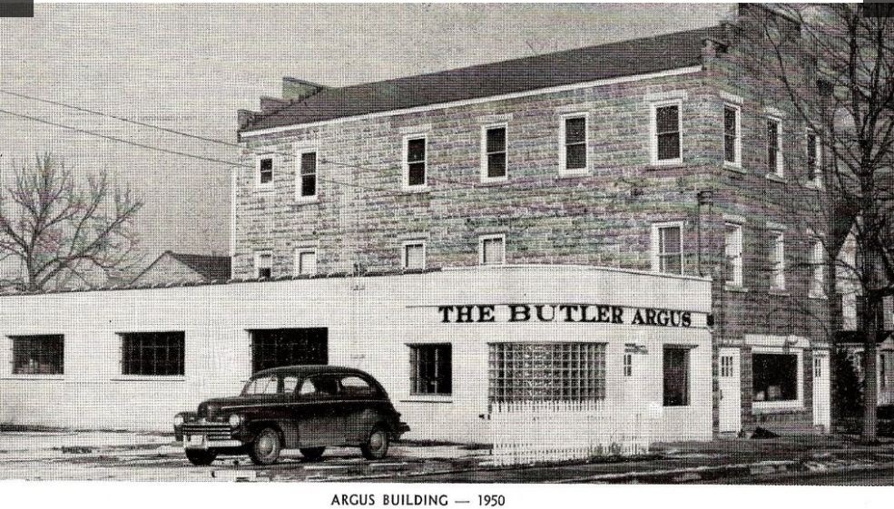
Down around the bend you’d spot Butler Coal & Lumber, across the street by the tracks, before arriving at Martin Cook’s Riverside Hotel. If you chose to go further, you’d find yourself at the Butler Argus building, where the next edition was being readied for printing. After that, you’d find yourself crossing the bridge into Union Square… but that’s another post.
If you’ve enjoyed this trip down memory lane, why not let me know? And credit is due to the Butler Museum, which is housed in the historic, brick-red New York, Susquehanna and Western railroad station. Many of the stores listed came from their do-it-yourself tour of Butler, using their Museum Historic Address Highlights page. The museum is well worth a visit.
Finally, as you might note, parking along Main Street was something of an issue then. The newly-formed Butler Business Men’s Association would meet (the same week as these photos, coincidentally) to discuss possible solutions.
Today, there’s parking on both sides from Park Place on up – but that wasn’t possible until the second set of tracks was removed at some point.
The Tri-Angle Lodge stood “2 miles West of Newfoundland NJ,” according to the postcard. The building, which still stands, is on the north side of Route 23 at Canistear Road.
The Lodge was owned and operated by the Arrouge family who owned it from about 1928 until the early 1960s. Gertrude Pittenger (or Pettinger) Arrouge and her son, Dwight, ran it day to day. Some locals still remember walking to the Lodge in their youth to purchase candy, gum, or cigarettes.
The Tri-Angle Lodge in the 1930s. Note the Texaco gas pump at right.
You could also fill your tank up your car with genuine Texaco gasoline. Some remember serenading Dwight with the Texaco jingle when a car would pull up.
The 1950 Census shows Gertrude Arrouge living there with her daughter Joan, Joan’s son, and two lodgers named Card. (Gert’s husband, Emil, died in 1931.)
The Lodge also offered “home cooking” for the hungry, including sandwiches and chicken dinners. You could even hire them to host a dinner party. If you just wanted a snack, you could use the walk-up window.
Evidently known both as “Triangle” and “Tri-Angle”, the Lodge offered “refreshments of all kinds.”
Interestingly, Gertrude’s father, Warren Pettinger, was a “dowser” – a person who could locate water with only a Y-shaped tree branch. A newspaper article, published shortly before he died in 1947, noted that he claimed to have dowsed for – and located – water sources 328 times.
The Lodge building is still there, known as the Razor Tune Ski Shop. It still looks much the same, but has no connection to its countryside past.
“Pompton Plains, New Jersey” is a famous painting by Jasper Francis Cropsey from about 1867.
Opinions differ on just where Mr. Cropsey placed himself while painting this wonderful view of the Pompton Valley. (Maybe if you could find that boulder…) You can see the Pompton River in the foreground; some speculate that the Morris Canal feeder dam lay just beyond the bend.
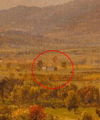
But if you look closely, right there in the center, is the First Reformed Church of Pompton Plains. (I’ve written about this church before.)
Do you see it? It’s way off in the distance. If you need a hint, here you go. (You can also click on the image above to see it vastly enlarged.)
We modern folk need to keep in mind that, in the 19th Century, the Pompton Valley was pretty empty. There were few buildings, and vast portions weren’t covered by trees as is the case today.
Other buildings in Cropsey’s painting may be identified. For example, this one – to the right of the church – appears to show the Martin Berry House and a barn in front of it. Look for the gap between the mountains in the full-sized image.
Since we know where the church is, it may be possible to identify some of the buildings on either side from other sources.
“Pompton Plains, New Jersey” may be seen at the Metropolitan Museum of Art.
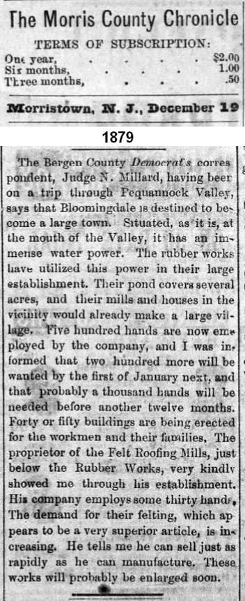
There was a time when the people of Bloomingdale, which at that time included the north end of Riverdale (“East Bloomingdale”) and most of Butler (“West Bloomingdale”), desired to form a new county. They envisioned taking parts of five counties to form “Pequannock County” — with Bloomingdale as the county seat, of course.
This effort failed, but ultimately Bloomingdale would become an independent borough when Pompton Township was broken up in 1918.
A companion article in the same 1879 newspaper explained why Bloomingdale anticipated a bright future accompanied by both industrial and residential growth.
The creation of the Civilian Conservation Corps was President Roosevelt’s grand plan to put some of America’s hundreds of thousands of unemployed young men to work during the Depression. This was one part of his “New Deal” that was a success. These men — often merely boys — were put to work on a variety of environmental programs such as planting trees and battling mosquitos. Between 1933 and 1942, more than three billion trees were planted, and many miles of trails were built in more than 800 parks nationwide.
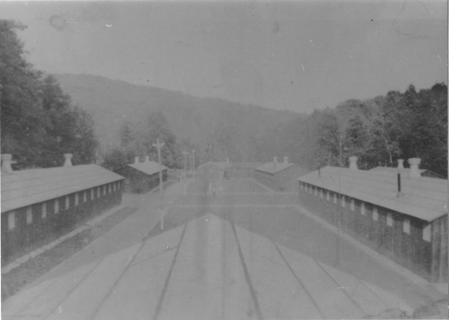
In Morris County there were two camps: One at Oak Ridge (roughly in the Cozy Lake Road area) and one in Butler. Almost nothing, other than its general location, is known about the Oak Ridge camp.
The Butler camp was designated Camp S-54, situated on the Pequannock River where Generant today manufactures industrial parts.
Looking north from the camp. I believe that’s Kanouse Mountain in the background.
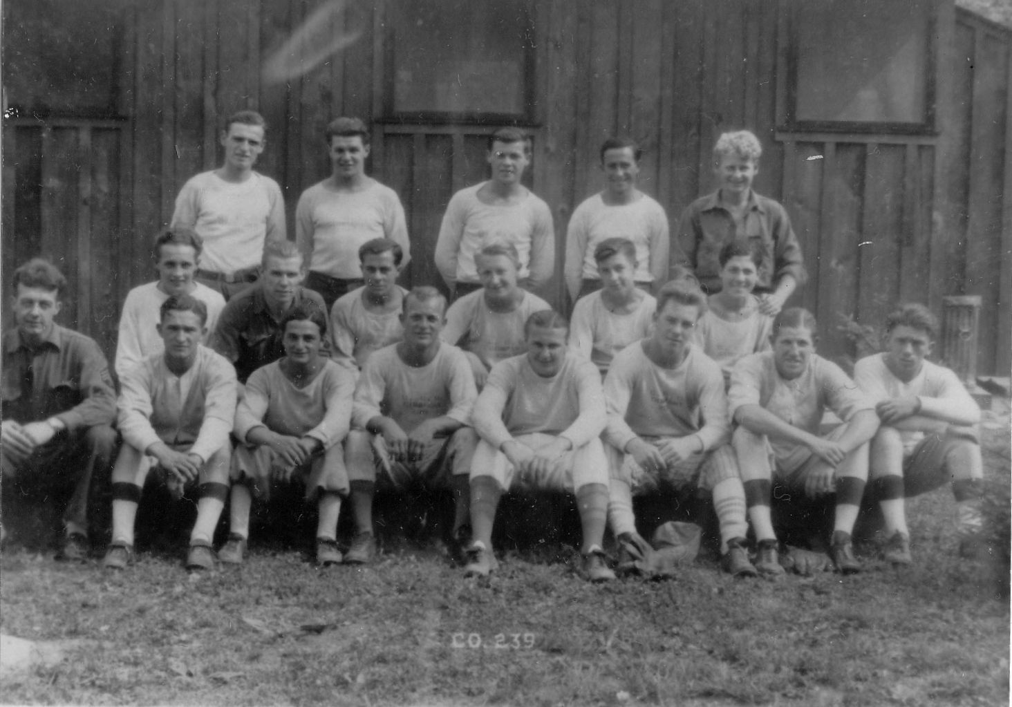
From surviving photos in the collection of the Butler Museum, it was a pretty large camp. Several barracks buildings held several hundred men. It had all the comforts of home, so to speak, and like other CCC camps, was generous with the chow, as young boys needed to keep their strength up for what was arduous work — planting trees in the surrounding region and clearing trails for hikers.
Under the guidance of the U.S. Forest Service, the National Park Service and the Departments of the Interior and Agriculture, CCC employees fought forest fires, planted trees, cleared and maintained access roads, re-seeded grazing lands and implemented soil-erosion controls.
Additionally, they built wildlife refuges, fish-rearing facilities, water storage basins and animal shelters. To encourage citizens to get out and enjoy America’s natural resources, FDR authorized the CCC to build bridges and campground facilities.
An existing railroad line on the opposite side of the river was utilized to drop off supplies. The boys made regular R-and-R trips to nearby Butler as well as Paterson.
These photos and others are from the Butler (NJ) Museum. There is also a collection of the newsletters published there filled with news and gossip, attesting to the high spirits of the CCC members. Today, nothing remains of the camp.
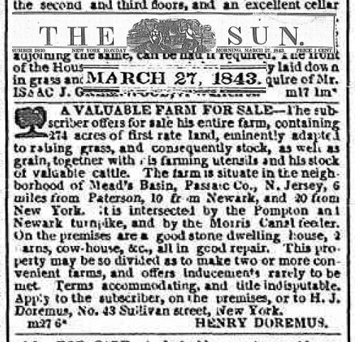
In 1843, Henry Doremus of Wayne offered “a valuable farm for sale.” It contained 274 acres of first rate land.
In real estate, location is everything: “The farm is situate in the neighborhood of Mead’s Basin, Passaic Co., N. Jersey, 6 miles from Paterson, 10 from Newark, and 20 from New York. It is intersected by the Pompton and Newark turnpike, and by the Morris Canal feeder.”
Ad in the NY Sun for the Henry Doremus farm.
Mead’s Basin was in Mountain View, and the “basin” was a large pond where canal boats traveling on the Morris Canal could tie up for the night to shop or to dine. The basin was the parking lot by (the now closed) Mother’s, formerly Gabriel’s.
The offer was for lock, stock and barrel: “On the premises are a good stone dwelling house, 2 barns, cow-house, etc., all in good repair.” We can only wonder whether that house still stands, given that so much history has given way to strip malls, road widenings, and housing developments.
What became of Henry Doremus? The family was quite well known in the region, and a search reveals dozen of potential matches by that name. A Henry Doremus served as the postmaster at Mead’s Basin in the early days of the Morris Canal, but who knows?
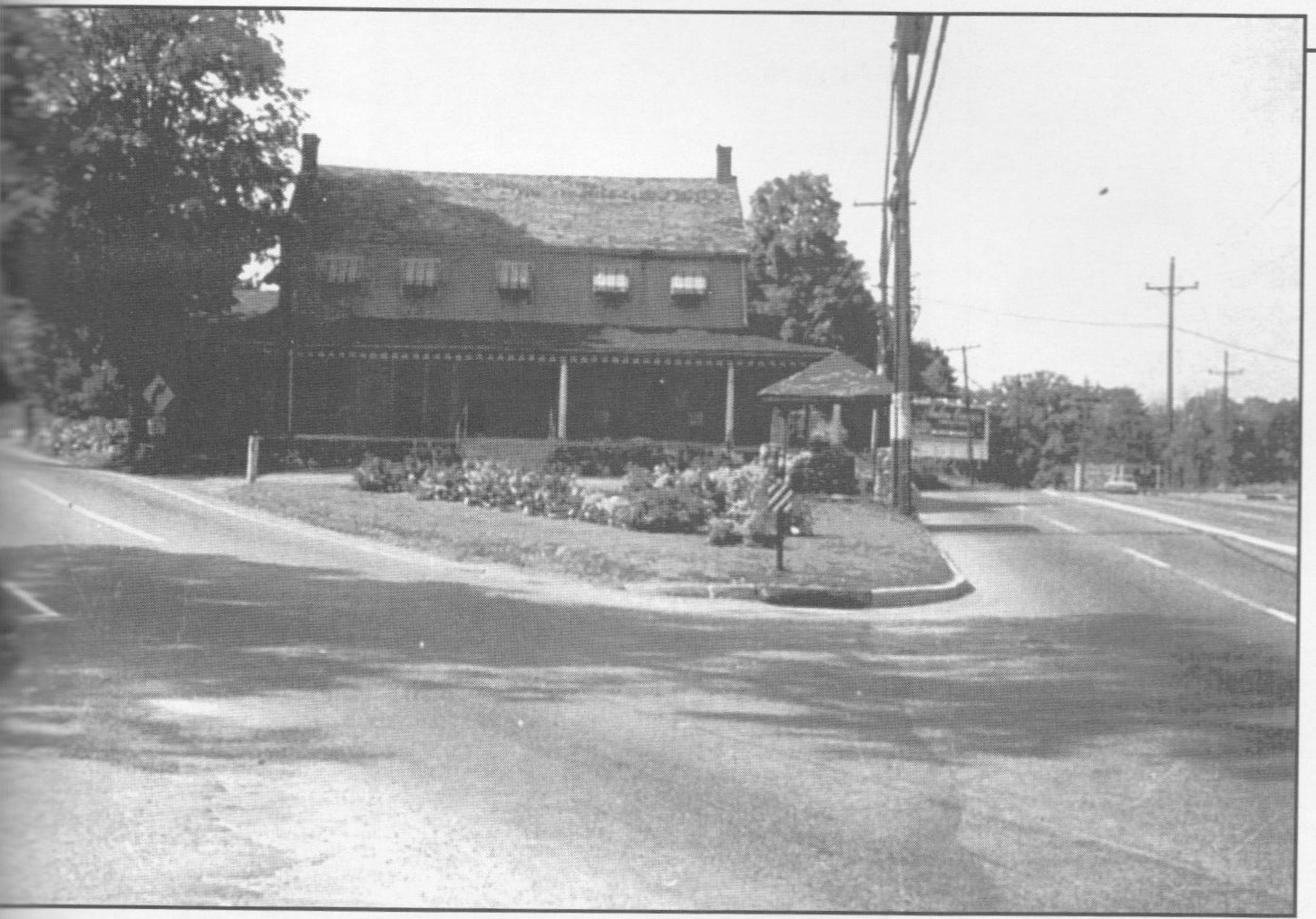
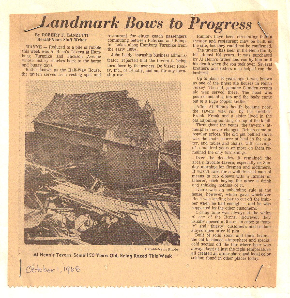
The 19th-Century building known as Henn’s Tavern stood on the corner of Jackson Ave and Hamburg Turnpike from the mid-1850s until it was torn down in 1968. The place had been in the Henn family for almost a hundred years.
Henn’s stood at the intersection of Jackson Ave and Hamburg Turnpike. Note the water tower in the background, still there today.The billboard touts Sportland, a large recreational area on Route 3 in the Meadowlands.Click the photo for a larger version.
The locals called it the Coop, the Henn house, or the Half-Way house — it was halfway between Paterson and the Norton House in Pompton Lakes — and they came for Al Henn’s 25-cent whiskey and 10-cent beer chaser … and to pass the time of day. Mabel Henn did the cooking, making both lunch and dinner, which might include game bagged by local hunters.
The name “Half-way House” was well deserved:
More than a hundred years ago, when people journeyed from Paterson to the Hamburg Turnpike and to upcounty areas, it took them at least an hour by horse and carriage to make the uphill journey into Wayne.
Perhaps the reason why the older generation feel winters used to be more severe is because they didn’t have the convenience of heated cars. One shivers at the thought of them riding behind clopping horses, huddled up in their blankets, noses red as cherries.
In those days, there were way stations where travelers could pause, rest their horses, have a hot drink, and warm up before a fire. Henn’s Tavern was one of those early stage coach, stops, and if buildings could speak it would have many stories to tell.
The Henns also had a 32-acre farm where they raised pigs. Around what is now Old Homestead Road was a baseball field which the locals called Al Henn’s field. Some area residents recall that dugouts were added at some point, and that P.A.L. baseball was played there. Al Henn field was the only ball field in town besides the Valley High School varsity field with dug outs.
(I don’t know whether Mr. Henn was responsible for constructing the field. If any readers have some insight, please feel free to leave a comment or send me an email.)
In those days there was a bus stop across Jackson Avenue by Old Homestead Road. As one resident recalls, Mr. Henn walked down to the corner every morning to open up the barn across the street so all the kids on Old Homestead Road had a place to wait for the bus away from the weather.
This 1968 newspaper article noting its passing says that the house was a stagecoach stop in the 1800s, and that it had been in the Henn family “for almost 100 years.”
Click the photo for a larger version.
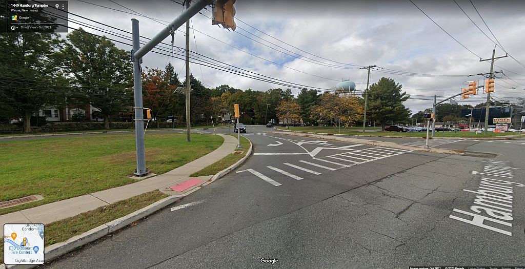
Here’s the same location today.
Gone but not forgotten
Unsurprisingly, many deplored the destruction of yet another bit of Wayne’s history. Henn’s ballfield, the site of hundreds of baseball games, was sold in 1974 and became the site of luxury homes. Across the Turnpike, the restaurant called The Gaslight turned into Victoria Station and others before the property was sold for assisted-living condos.
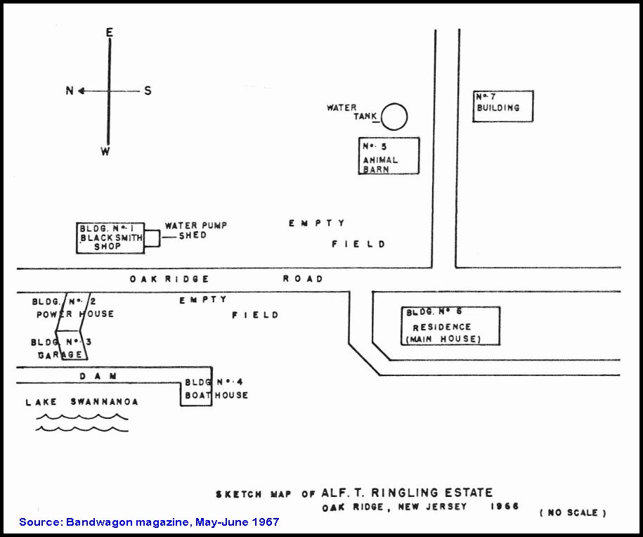
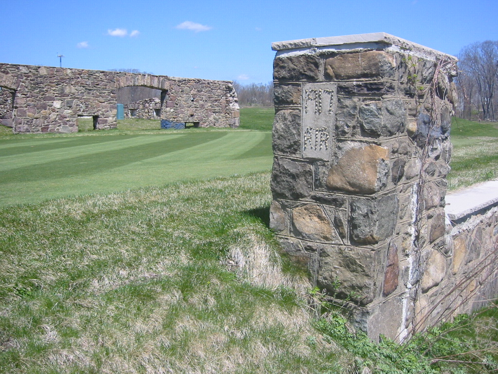
Alfred T. Ringling, he of circus fame, discovered the picturesque Berkshire Valley in the early 20th Century. Declaring it the most beautiful place he had ever seen, he purchased 100 acres and a pond in Petersburg (now the Milton section of Oak Ridge) and set about building a winter HQ for his circus. A 26-room mansion was built between 1917 and 1918, along with a series of outbuildings for his circus menagerie. Most of them survive today, in private hands.
A sketch map from 1966 locating (with some errors) the Ringling outbuildings.
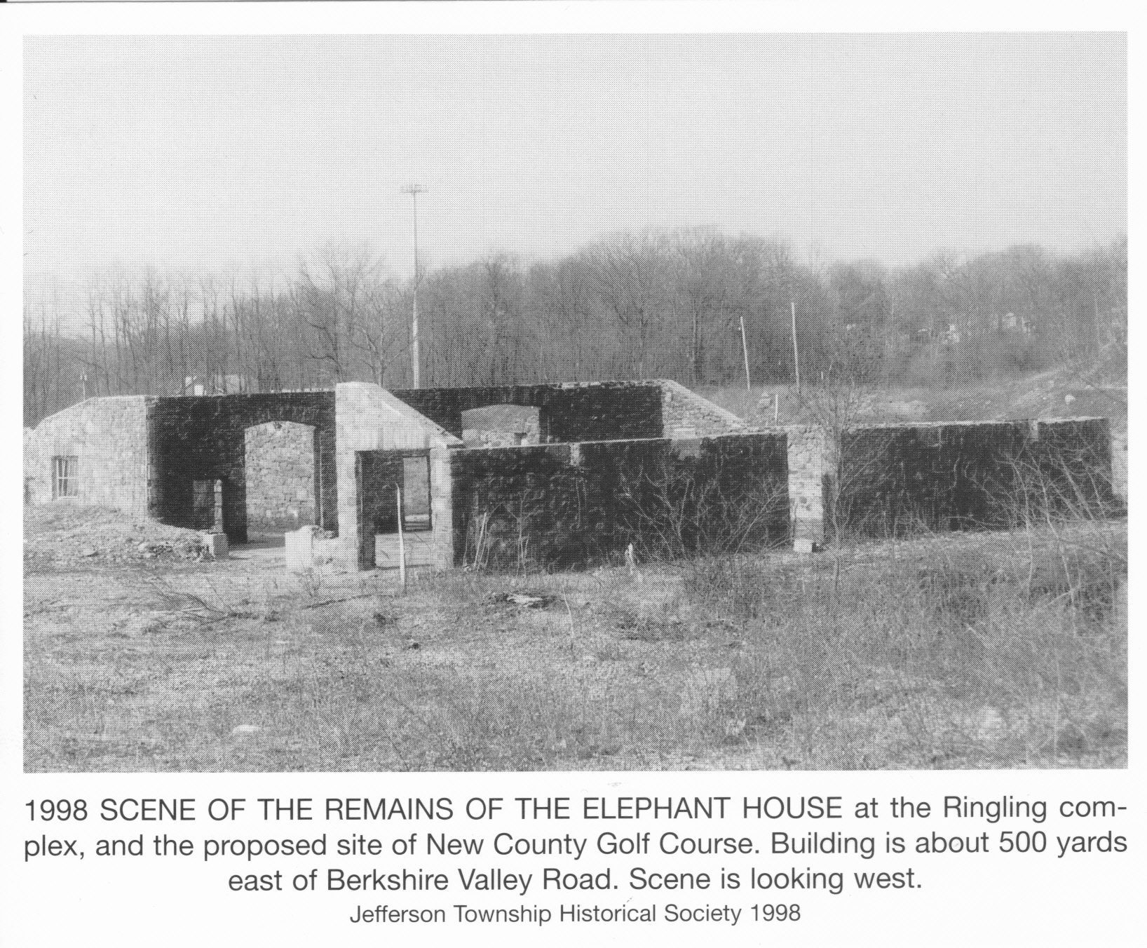
The “No, 7 building” in the sketch map denotes the elephant building. Like the others, it was concrete with area fieldstone decorating the walls. It’s gone to ruin — the glass-roofed ceiling collapsed about 1996, according to the locals — but what’s left has been incorporated into the Berkshire Valley Golf Course.
These postcards from 1998 show the elephant house ruins when the area was being used as a quarry. (Jefferson Twp Historical Society)
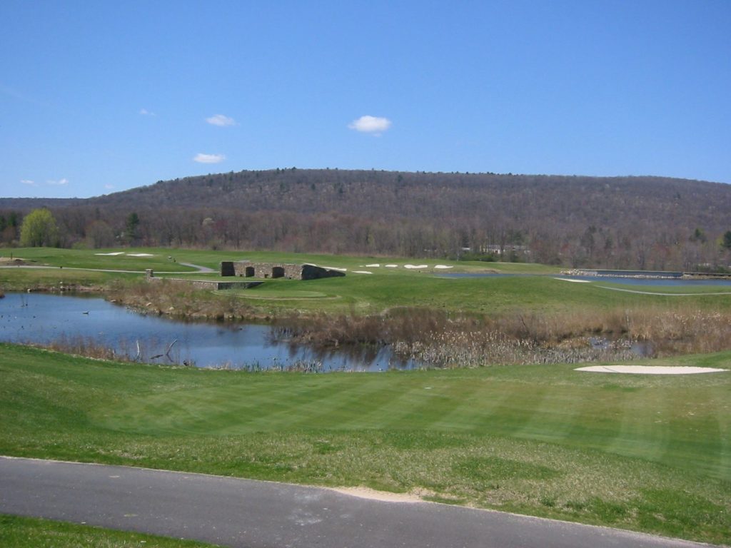
I took the following photos in the spring of 2004 when the property was being transformed into the golf course.
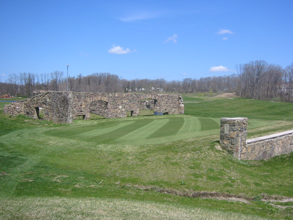
A view of the Ringling elephant house ruins. In the distance, to the right, is another Ringling building, now occupied by Jefferson Medical Imaging.(Photo by Paul Havemann)View of the Ringling elephant house ruins. The floor sloped down beneath the sloped ceiling. (Photo by Paul Havemann)
These close-up photos give an idea of the size of the place.
My favorite view of the Ringling elephant house from 2004, back when the Berkshire Valley Golf course was under construction. (Photo by Paul Havemann)The inlaid stones on the pillar (at right) spell out the year the elephant house was built — 1917 — and ‘RTR’ for Robert T. Ringling, who took over the circus after Alfred Ringling died. (Photo by Paul Havemann, 2004)
Today, the Berkshire Valley Golf Course plays host to thousands of golfers every year. As a county golf course, it’s open to the public. Food and drink are available in the clubhouse, even if you don’t golf. And you’re able to borrow a golf cart and head over to the ruins yourself, if you wish.
There once was a lovely village called Newfoundland, up West Milford/Jefferson way. A landmark of the area was Brown’s Inn, a lovely four-story hotel renowned all over for its hospitality and unrivalled peace and quiet. It stood on what was then the Paterson-Hamburg Turnpike, which we know today as Route 23 South, just across from Green Pond Road. Gone now, of course; that’s the way of old hotels. But the story of the Inn is for another post.
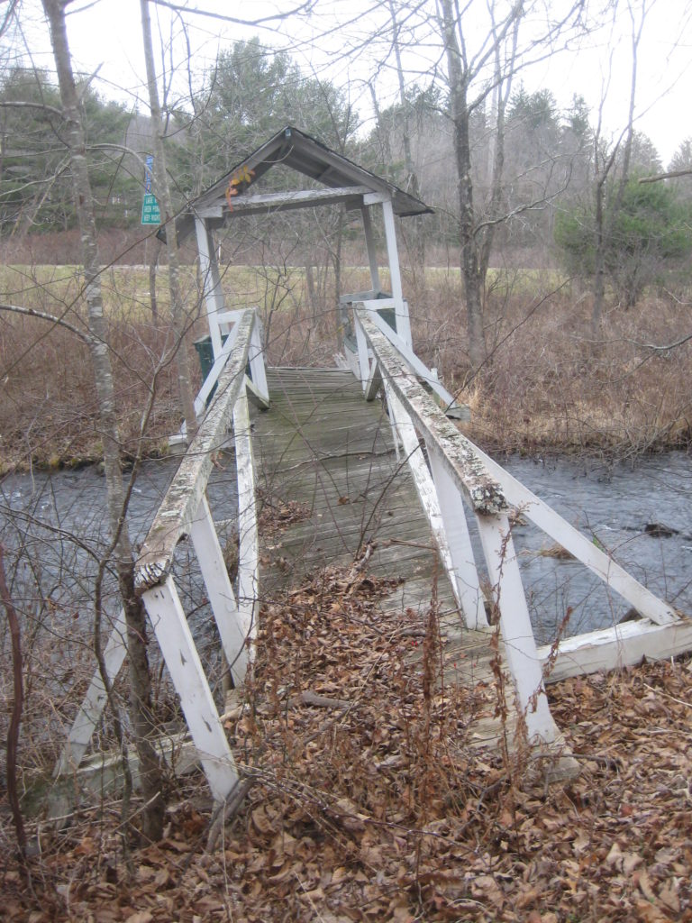
Behind the Inn was a meadow crossed by the quiet Pequannock River. (There wouldn’t be a “northbound 23” until many years later.) Across the river stood the old Brown homestead, a nice little cottage. To get to it you would traipse across a lovely and well-made footbridge. No one can recall just when it was built — my earliest postcard view is from 1909, and it was likely constructed sometime in the 1800s — but it endured for over a century.
Brown’s homestead footbridge, circa 1909.
Here’s a close-up of the footbridge. Anchored on both sides, the ‘cabin’ was held up by three iron rods anchored to a boulder in the river. If you liked, you could sit in the little cabin and while away some time.
Perhaps the best view of the footbridge.
This is a view from one of the upper stories of Brown’s Inn. It shows a peaceful, tranquil, and unpaved meadow with a path from the homestead to the footbridge.
But as idyllic as it all seemed, Brown’s Inn was “a source of annoyance” to the City of Newark. Since the late 1890s, Newark had been buying land in upper Passaic County, and constructing dams and reservoirs, to supply it with fresh, clean water. Brown’s represented a problem to its campaign to prevent pollution from entering in its water supply.
Negotiations dragged on for a decade before a sale was made. Brown’s Inn was purchased, and then razed, in 1914.
In the early 1960s, Route 23 was “dualized” by the addition of two northbound lanes which came uncomfortably close to the homestead. As part of the project, the riverbed was actually “relocated”, in the state’s terminology, to make way for the new northbound lanes. (It is unlikely that such an action would be as readily granted today.)
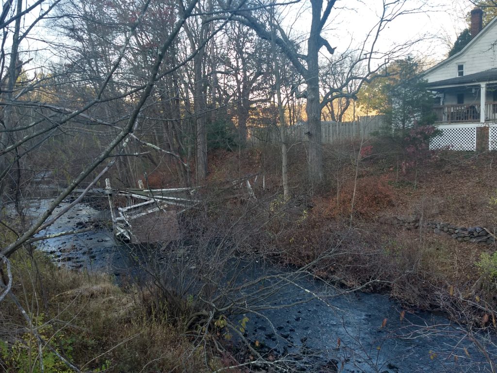
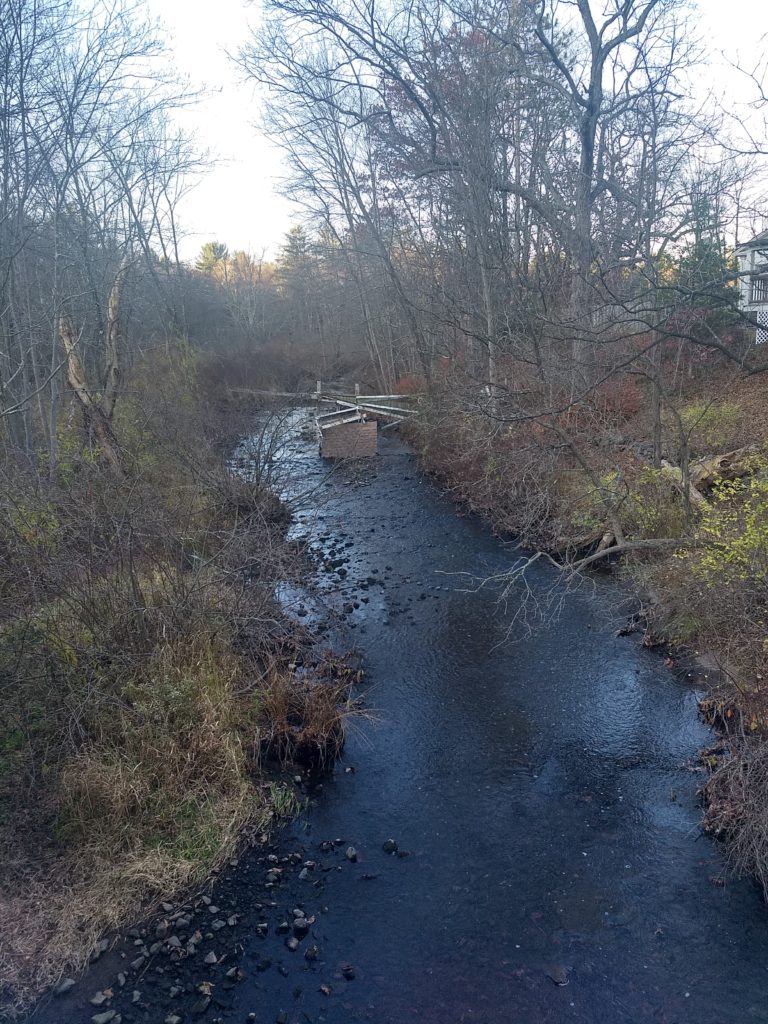
And so the footbridge slumbered, unused. The half closest to the highway collapsed decades ago, and even when it was passable, there was nowhere to go except to climb the embankment to the highway.
My own photo, taken with permission from the tenant in 2015.Note that the right side is entirely gone.
My own photo, taken with permission from the tenant.I was not brave enough to risk getting on it!
The end finally came in the fall of 2020, when the old bridge couldn’t take it any more.
Harvesting, storing, and selling ice was a major industry from before the 1800s until the late 1940s, when refrigerators became common in the home. Every lake and pond that could produce a decent quantity of ice was harvested all winter. In our region, that included the rural areas of Lake Hopatcong, Greenwood Lake, Charlotteburg Lake, Echo Lake (also known as Macopin Lake, Lake Macopin, and Macopin Pond), and the topic of this post, Greenwood Pond in the Oak Ridge section of West Milford.
Ice was a major source of employment. Companies would hire as many men (and teenaged boys) as they would need, as well as farmers and their horse teams who were idle during the winter. In warm weather, route men were needed to supply homes and businesses with the ice harvested in the winter. Ice was always needed by homes, hotels, and other businesses in the cities and vacation areas.
Winters were colder two centuries ago; ice would form by November, growing to over a foot thick, and still be available for harvest as late as mid-March.
Greenwood’s Silk City Ice Company boasted that its Oak Ridge ice was “pure”
Around 1897, Edward R. Greenwood founded what would become a prosperous coal business in Paterson. Two years later, he started a new venture, the Silk City Ice Company, alongside his E.R. Greenwood Coal & Ice Company. Initially, he imported ice from the Poconos. Wanting a more local source, around 1907 he purchased Greenwood Pond and surrounding lands, and constructed a dam to enlarge the pond. The pond and the dam still exist on Bonter Road (which was then called Icehouse Road), not far from Oak Ridge Road.
Greenwood built a large ice house ideally located between the shore of the 4.5-acre pond and the NY Susquehanna & Western (NYS&W) railroad line. A siding brought railroad cars alongside the ice house to be packed with ice cakes bound for Paterson.
A typical ice house would be quite large and several stories tall. Greenwood’s was perhaps 50 by 150 feet, between 40 and 50 feet tall. Echo Lake had one, as did Lake Hopatcong, while Greenwood Lake boasted two, both owned by the Hewitt family.
They were all built the same way: the outside walls were built of wide boards, and another such wall was constructed on the inside. An ice house would be divided into several rooms, with the dividing walls built the same way. The gap between them was filled with sawdust for insulation, while salt hay was used in the individual rooms.
View of gasoline-powered ice saw in front of the Greenwood ice house.
Ice harvesting was grueling work. Teams of men would work 10- to 12-hour days; they were well-paid and, at some ice houses, also well-fed. At Greenwood, an early-morning steam whistle signaled that the ice was ready for harvest. Between 30 and 40 day workers would congregate at the pond as a crew would plow any snow off the ice. One team would carefully score a checkerboard pattern in the ice; this was necessary to ensure uniform ice blocks. Other teams would begin the cutting process. Originally the ice was manually sawed into long blocks using specially-designed saws. By the 1920s, gasoline-powered ice saws replaced that manual labor. (A gas-powered ice saw is on display at the Long Pond Iron Works in Hewitt, NJ.) The men would break for coffee as well as a hearty lunch.
The ice blocks were floated to a long conveyor belt where they were cut into cakes; a steam-engine-powered conveyor lifted them into the ice house where they would be stacked among the rooms. It might take several days to fill the Greenwood icehouse, while the two much larger icehouses at Greenwood Lake might require weeks.
Side view of the Greenwood icehouse. Note the steam-driven conveyor belt.Bonter Road (then called Icehouse Road) is to the right.
All ice houses needed a delivery system for their product. Before the advent of railroads, much was packed into canal boats and sent down the Morris Canal. By the 1830s, railroads were much faster and could handle much more product. The same railroads that delivered vacationers to idyllic spots such as Brown’s Inn in Newfoundland could return to Paterson with a profitable payload. Greenwood Pond had a siding constructed to the railroad line just yards away, while Echo Lake had a dedicated, 1.5-mile railroad line (the Macopin Lake Railroad) connected to the NYS&W.
Railroad cars would arrive at Greenwood’s icehouse on a siding off the roadway.
Once packed with ice blocks, the railroad would take the ice to various destinations for delivery. Greenwood didn’t market his ice in Oak Ridge, but local people, and some shop keepers, would come to the ice house to purchase bags of ice chips that resulted from shaping the ice cakes.
A 1906 ad for Silk City Ice. Before purchasing Greenwood Pond, he obtained his ice from “Mount Poconoke” in neighboring Pennsylvania.
Silk City Ice sold ice in quantity to big hotels and such, but also maintained eight local routes in Paterson and Totowa. Each of the eight route men had his own horse-drawn ice wagon from which to sell ice to housekeepers and small stores.
Newspaper accounts paint a portrait of a fair and generous boss:
E.R. Greenwood, coal and ice dealer of this city, gave a theatre party and banquet to his employees and their wives as a means of expressing his appreciation of the good work done by the men in harvesting the ice crop, during which time they labored day and night.
After watching a play at the Lyceum theatre, the party partook of a well prepared supper in a local restaurant. The ladies were presented with large boxes of chocolates, while the men received cigars.
Paterson Morning Call, 01 Feb 1917
A Silk City Ice delivery wagon of the era.
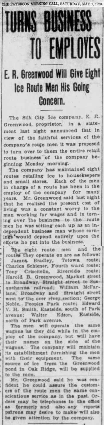
In late 1920, Greenwood turned over the retail route business of Silk City Ice to eight of his long-time faithful employees. According to a 1920 newspaper article, he realized that the present cost of living was a constant worry to the man working for wages. In turning over the business to the route men, he set each up as an independent business man whose earnings would depend entirely upon the efforts he put into the business. Each man also was gifted the wagon each had been using, and had their names painted on the sides. The ice would continue to be harvested in Oak Ridge.
Click the article for a full-sized version.
By the 1930s, however, the writing was on the wall for the ice harvesters. The invention of the refrigerator, and the introduction of “artificial ice” made in commercial freezers at ice plants, would soon doom the ice-harvesting industry. “Mechanical iceboxes”, which used a liquid refrigerant to produce cold, had been invented in 1915 as an add-on to the traditional icebox. By the mid-1920s, the modern refrigerator was available for purchase, but only the wealthy could afford them; it would take decades before they became affordable to many families.
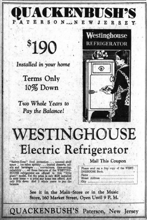
This 1931 ad touts a household refrigerator for $190. That translates to about $3,400 in today’s dollars!
Apparently, harvesting came to a close in the late 1930s, and the ice house was abandoned. Eventually, it collapsed; the wooden structure has long since returned to the earth. The railroad siding is long gone. The concrete foundation and footings, and some iron hardware, however, still survive, bearing mute testimony to a bygone industry.
There is little left of the Greenwood ice house today.