(This is a continuation of the original post that you can find here.)
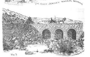
I found this line drawing in an 1891 journal titled Engineering Record, in an article titled Construction of the East Jersey Water Company’s Aqueduct and Reservoirs. It’s a lengthy account of the massive undertaking of building five reservoirs in north Jersey for the benefit of Newark.
So this line drawing is described thus: “Figure 3 is a view of the three-arch bridge carrying the new highway across an arm of the Oak Ridge reservoir. At full stages of the water these arches will be completely submerged.”
Which, of course, they are, as per the first blog post. If you’re lucky to be there during a drought, you too can see it… even walk on it, if you dare.

The “new highway” wasn’t all that new; it was the Paterson-Hamburg Turnpike, first chartered in 1806 and improved over the years. At the time the Oak Ridge reservoir was under construction, the roadway ran right along the shore of the river. But since the reservoir would flood the valley, the roadway would have to be moved to higher ground, which it was, sometime around 1927.

In this postcard photo we see the original route of the Paterson-Hamburg Turnpike (also known, at that time, as Route 8) which followed the eastern shore of the reservoir. The ridge supporting the railroad is visible on the right, well above the roadway.
And if you examine the photo closely (or click on it to open it up full size), at lower left is the old bridge that led to the village of Oak Ridge.
Where the original roadway was not far above the water line, today’s highway is elevated several yards higher — almost level with those railroad tracks — to prevent any flooding issues. The highway was also straightened, such that it proceeds nearly north (to the left) of the roadway here, and very close to the bridge. Today, if you park on Route 23 South near the bridge, you look down on it, over a very steep incline, and from a much closer vantage than shown here.
Here’s a 2022 photo taken from about the same vantage as the late 1800s photo above. You, too, can trod on the original route of the Paterson-Hamburg Turnpike. (You would actually be trespassing. Go at your own risk; Newark Watershed patrols can be cranky.)

The next post in this series shows the reservoir practically dry, during the epic 1960s drought, in a truly impressive aerial photo.
-30-


