I’ve always wondered what the original, long-gone village of Oak Ridge was like before it was covered by the waters of the reservoir. There are hints in vintage letters and postcards, as well as in tales told by the descendants of those who lived there. If there are old photos, I have yet to find them.
This photo offers a glimpse of the original Oak Ridge village. Taken in 1965, it’s an aerial view of the reservoir, showing long-drowned roadways. If you think 2024’s drought is bad, this was worse. The 1960s drought, which occurred from late 1962 to 1966, was deemed the most severe drought in the northeast United States over the last century [cite].
The Oak Ridge Reservoir in 1965. Click for full-sized photo.
In this photo, the view is looking the south/southeast. The Pequannock River enters the valley at lower right, meandering its way along the bed. Route 23 is at the bottom… those small rectangles are cars on the highway. Unfortunately, the ghost bridge is just outside this photo. You can, however, see a number of roadways heading north/south and east/west – something I did not see on my early-November visit. The small hamlet of Wallace Corner is probably not in this photo either, but you can see the road(s) that would have taken you there.
You can also see – right above Route 23 – the original path of the Paterson-Hamburg Turnpike (as discussed here).
Should you choose to visit this 19th-Century artifact, know that the Newark Watershed has regular patrols of the area. In fact, in November 2024, the West Milford police were actively ticketing visitors for trespassing.
The Tri-Angle Lodge stood “2 miles West of Newfoundland NJ,” according to the postcard. The building, which still stands, is on the north side of Route 23 at Canistear Road.
The Lodge was owned and operated by the Arrouge family who owned it from about 1928 until the early 1960s. Gertrude Pittenger (or Pettinger) Arrouge and her son, Dwight, ran it day to day. Some locals still remember walking to the Lodge in their youth to purchase candy, gum, or cigarettes.
The Tri-Angle Lodge in the 1930s. Note the Texaco gas pump at right.
You could also fill your tank up your car with genuine Texaco gasoline. Some remember serenading Dwight with the Texaco jingle when a car would pull up.
The 1950 Census shows Gertrude Arrouge living there with her daughter Joan, Joan’s son, and two lodgers named Card. (Gert’s husband, Emil, died in 1931.)
The Lodge also offered “home cooking” for the hungry, including sandwiches and chicken dinners. You could even hire them to host a dinner party. If you just wanted a snack, you could use the walk-up window.
Evidently known both as “Triangle” and “Tri-Angle”, the Lodge offered “refreshments of all kinds.”
Interestingly, Gertrude’s father, Warren Pettinger, was a “dowser” – a person who could locate water with only a Y-shaped tree branch. A newspaper article, published shortly before he died in 1947, noted that he claimed to have dowsed for – and located – water sources 328 times.
The Lodge building is still there, known as the Razor Tune Ski Shop. It still looks much the same, but has no connection to its countryside past.
Harvesting, storing, and selling ice was a major industry from before the 1800s until the late 1940s, when refrigerators became common in the home. Every lake and pond that could produce a decent quantity of ice was harvested all winter. In our region, that included the rural areas of Lake Hopatcong, Greenwood Lake, Charlotteburg Lake, Echo Lake (also known as Macopin Lake, Lake Macopin, and Macopin Pond), and the topic of this post, Greenwood Pond in the Oak Ridge section of West Milford.
Ice was a major source of employment. Companies would hire as many men (and teenaged boys) as they would need, as well as farmers and their horse teams who were idle during the winter. In warm weather, route men were needed to supply homes and businesses with the ice harvested in the winter. Ice was always needed by homes, hotels, and other businesses in the cities and vacation areas.
Winters were colder two centuries ago; ice would form by November, growing to over a foot thick, and still be available for harvest as late as mid-March.
Greenwood’s Silk City Ice Company boasted that its Oak Ridge ice was “pure”
Around 1897, Edward R. Greenwood founded what would become a prosperous coal business in Paterson. Two years later, he started a new venture, the Silk City Ice Company, alongside his E.R. Greenwood Coal & Ice Company. Initially, he imported ice from the Poconos. Wanting a more local source, around 1907 he purchased Greenwood Pond and surrounding lands, and constructed a dam to enlarge the pond. The pond and the dam still exist on Bonter Road (which was then called Icehouse Road), not far from Oak Ridge Road.
Greenwood built a large ice house ideally located between the shore of the 4.5-acre pond and the NY Susquehanna & Western (NYS&W) railroad line. A siding brought railroad cars alongside the ice house to be packed with ice cakes bound for Paterson.
A typical ice house would be quite large and several stories tall. Greenwood’s was perhaps 50 by 150 feet, between 40 and 50 feet tall. Echo Lake had one, as did Lake Hopatcong, while Greenwood Lake boasted two, both owned by the Hewitt family.
They were all built the same way: the outside walls were built of wide boards, and another such wall was constructed on the inside. An ice house would be divided into several rooms, with the dividing walls built the same way. The gap between them was filled with sawdust for insulation, while salt hay was used in the individual rooms.
View of gasoline-powered ice saw in front of the Greenwood ice house.
Ice harvesting was grueling work. Teams of men would work 10- to 12-hour days; they were well-paid and, at some ice houses, also well-fed. At Greenwood, an early-morning steam whistle signaled that the ice was ready for harvest. Between 30 and 40 day workers would congregate at the pond as a crew would plow any snow off the ice. One team would carefully score a checkerboard pattern in the ice; this was necessary to ensure uniform ice blocks. Other teams would begin the cutting process. Originally the ice was manually sawed into long blocks using specially-designed saws. By the 1920s, gasoline-powered ice saws replaced that manual labor. (A gas-powered ice saw is on display at the Long Pond Iron Works in Hewitt, NJ.) The men would break for coffee as well as a hearty lunch.
The ice blocks were floated to a long conveyor belt where they were cut into cakes; a steam-engine-powered conveyor lifted them into the ice house where they would be stacked among the rooms. It might take several days to fill the Greenwood icehouse, while the two much larger icehouses at Greenwood Lake might require weeks.
Side view of the Greenwood icehouse. Note the steam-driven conveyor belt.Bonter Road (then called Icehouse Road) is to the right.
All ice houses needed a delivery system for their product. Before the advent of railroads, much was packed into canal boats and sent down the Morris Canal. By the 1830s, railroads were much faster and could handle much more product. The same railroads that delivered vacationers to idyllic spots such as Brown’s Inn in Newfoundland could return to Paterson with a profitable payload. Greenwood Pond had a siding constructed to the railroad line just yards away, while Echo Lake had a dedicated, 1.5-mile railroad line (the Macopin Lake Railroad) connected to the NYS&W.
Railroad cars would arrive at Greenwood’s icehouse on a siding off the roadway.
Once packed with ice blocks, the railroad would take the ice to various destinations for delivery. Greenwood didn’t market his ice in Oak Ridge, but local people, and some shop keepers, would come to the ice house to purchase bags of ice chips that resulted from shaping the ice cakes.
A 1906 ad for Silk City Ice. Before purchasing Greenwood Pond, he obtained his ice from “Mount Poconoke” in neighboring Pennsylvania.
Silk City Ice sold ice in quantity to big hotels and such, but also maintained eight local routes in Paterson and Totowa. Each of the eight route men had his own horse-drawn ice wagon from which to sell ice to housekeepers and small stores.
Newspaper accounts paint a portrait of a fair and generous boss:
E.R. Greenwood, coal and ice dealer of this city, gave a theatre party and banquet to his employees and their wives as a means of expressing his appreciation of the good work done by the men in harvesting the ice crop, during which time they labored day and night.
After watching a play at the Lyceum theatre, the party partook of a well prepared supper in a local restaurant. The ladies were presented with large boxes of chocolates, while the men received cigars.
Paterson Morning Call, 01 Feb 1917
A Silk City Ice delivery wagon of the era.
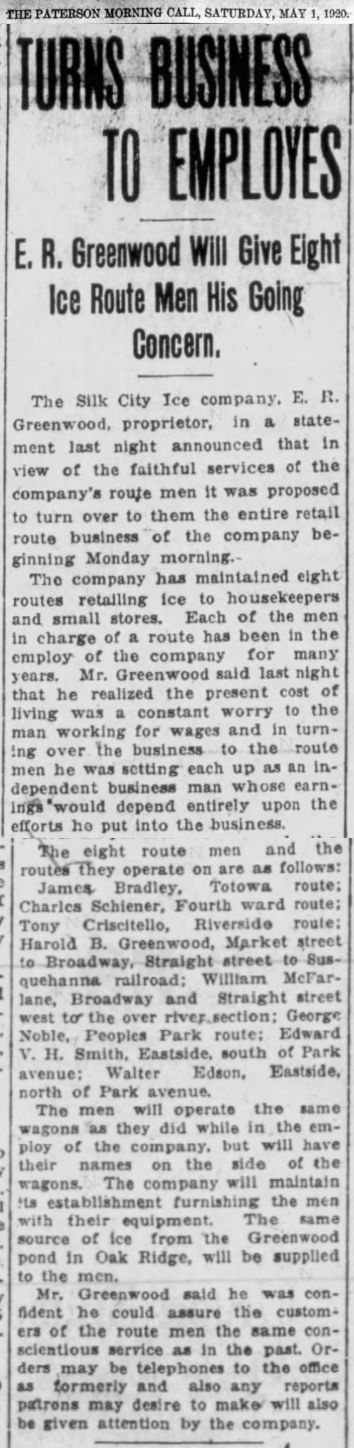
In late 1920, Greenwood turned over the retail route business of Silk City Ice to eight of his long-time faithful employees. According to a 1920 newspaper article, he realized that the present cost of living was a constant worry to the man working for wages. In turning over the business to the route men, he set each up as an independent business man whose earnings would depend entirely upon the efforts he put into the business. Each man also was gifted the wagon each had been using, and had their names painted on the sides. The ice would continue to be harvested in Oak Ridge.
Click the article for a full-sized version.
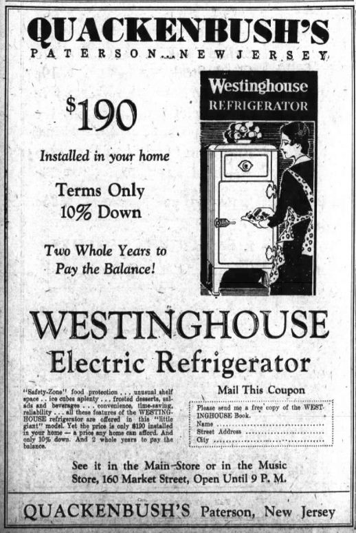
By the 1930s, however, the writing was on the wall for the ice harvesters. The invention of the refrigerator, and the introduction of “artificial ice” made in commercial freezers at ice plants, would soon doom the ice-harvesting industry. “Mechanical iceboxes”, which used a liquid refrigerant to produce cold, had been invented in 1915 as an add-on to the traditional icebox. By the mid-1920s, the modern refrigerator was available for purchase, but only the wealthy could afford them; it would take decades before they became affordable to many families.
This 1931 ad touts a household refrigerator for $190. That translates to about $3,400 in today’s dollars!
Apparently, harvesting came to a close in the late 1930s, and the ice house was abandoned. Eventually, it collapsed; the wooden structure has long since returned to the earth. The railroad siding is long gone. The concrete foundation and footings, and some iron hardware, however, still survive, bearing mute testimony to a bygone industry.
There is little left of the Greenwood ice house today.
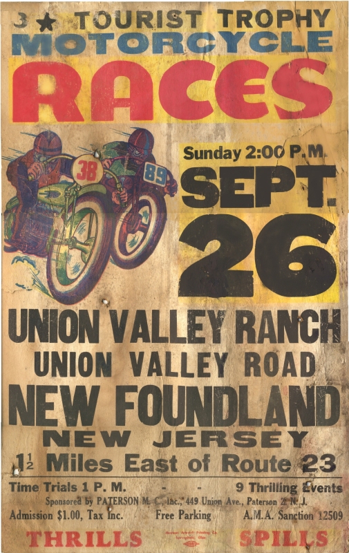
From 1948 to 1952, large crowds would gather on weekends at the Union Valley Dude Ranch — later renamed Newfoundland Speedway — in Newfoundland (a part of West Milford) to watch motorcycles race around a dirt track. A course had been built on a farm owned by Richard Boulden and his wife, Violet Cole, in the Bearfort Mountain range. The Paterson Motorcycle Club sponsored the races, which drew racers from states along the East coast. Families would gather on weekends throughout the spring, summer and fall for “a good day of sport and clean racing,” as a 1951 newspaper article put it.
1948 poster for motorcycle races at the Union Valley Ranch.
As many as 60 riders would compete in time trials and races along a newly-constructed 1/3 mile oval dirt track specially built for the sport. The track was 25 feet wide and featured a flat, dustless surface. A “dog leg” (sharp bend) heightened the excitement. Trophies and prize money were awarded. The novice trophy was especially prized.
Newspaperarticles like this helped bring the crowds.
Unsurprisingly, accidents and spills happened. Miscellaneous cuts and bruises were not uncommon; sometimes, broken bones resulted from a spill. West Milford’s Volunteer Firemen’s Ambulance Corps was on hand to help. A man with a broken collar bone would be taken to a local doctor, who would patch up the rider before sending him to a hospital in nearby Franklin. At times, their main ambulance would be busy, spurring them to station a second, auxiliary ambulance as well.
Occasionally, proceeds from a race would be given to the volunteer corps for “faithfully contributing their time and equipment for the protection of the drivers.”
Riders came from Pennsylvania, New Jersey, New York, and Connecticut to compete. Some riders achieved local fame. Don Pink, of Yonkers, was apparently a popular fellow, as was Cornwall, NY’s Warren Sherwood. Easton, PA was represented by Jack Brewer and Ken Wismer. Al Wilcox was known as the “Trenton Flash” and Al Scirpo, the “Hartford Flash”. Race results were published in local papers, and undoubtedly a few wagers would be placed.
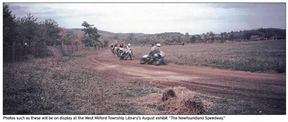
Photo from West Milford AIM (2012). Click for full-sized image.
In 1949 the track was christened the Newfoundland Speedway. There’s a great video of a race there on YouTube. Races were held every Saturday, and often on Sunday. The only exceptions were for larger motorcycle races such as the Gypsy Tour at the half-mile track on Route 6 (today’s Route 46) in Dover NJ — and, of course, rain.
The races came to be very popular. As many as twelve events were held, and the American Motorcycle Association would provide judges and timers.
The races ran almost every weekend through 1952, when the farm was sold. Today, it’s known as the West Milford Equestrian Center, and it is again up for sale.
There are some nice shots of races, and close-ups of the bikes, at this site.
(This is a continuation of the original post that you can find here.)
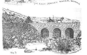
I found this line drawing in an 1891 journal titled Engineering Record, in an article titled Construction of the East Jersey Water Company’s Aqueduct and Reservoirs. It’s a lengthy account of the massive undertaking of building five reservoirs in north Jersey for the benefit of Newark.
So this line drawing is described thus: “Figure 3 is a view of the three-arch bridge carrying the new highway across an arm of the Oak Ridge reservoir. At full stages of the water these arches will be completely submerged.”
Which, of course, they are, as per the first blog post. If you’re lucky to be there during a drought, you too can see it… even walk on it, if you dare.
Ghost Bridge illustration (1891)
The “new highway” wasn’t all that new; it was the Paterson-Hamburg Turnpike, first chartered in 1806 and improved over the years. At the time the Oak Ridge reservoir was under construction, the roadway ran right along the shore of the river. But since the reservoir would flood the valley, the roadway would have to be moved to higher ground, which it was, sometime around 1927.
Looking north on the east shore of the Oak Ridge Reservoir, late 1890s. On the right is the railroad. (Click image for full-sized view.)
In this postcard photo we see the original route of the Paterson-Hamburg Turnpike (also known, at that time, as Route 8) which followed the eastern shore of the reservoir. The ridge supporting the railroad is visible on the right, well above the roadway.
And if you examine the photo closely (or click on it to open it up full size), at lower left is the old bridge that led to the village of Oak Ridge.
Where the original roadway was not far above the water line, today’s highway is elevated several yards higher — almost level with those railroad tracks — to prevent any flooding issues. The highway was also straightened, such that it proceeds nearly north (to the left) of the roadway here, and very close to the bridge. Today, if you park on Route 23 South near the bridge, you look down on it, over a very steep incline, and from a much closer vantage than shown here.
Here’s a 2022 photo taken from about the same vantage as the late 1800s photo above. You, too, can trod on the original route of the Paterson-Hamburg Turnpike. (You would actually be trespassing. Go at your own risk; Newark Watershed patrols can be cranky.)
View of the reservoir, and Route 23, from just about the same vantage point in 2024.Click to see full size.
The next post in this series shows the reservoir practically dry, during the epic 1960s drought, in a truly impressive aerial photo.
The Oak Ridge Reservoir was constructed in the 1890s to help supply Newark’s burgeoning populace with a supply of fresh water. It was one of several reservoirs in north NJ built at about the same time. (The others are Canistear, Charlotteburg, Clinton, and Echo Lake.)
A really good photo by Ron DuPont (c 2014) Click for full-sized article
The rural village of Oak Ridge was, unfortunately, right where the reservoir was planned to be — so Oak Ridge, and a smaller village known as Wallace Corner, had to be eliminated. Today, their locations are underwater. (If anyone knows of a map of the original villages, please let me know.)
But, as this article notes, an old three-arched stone bridge that once connected Oak Ridge to the main road — known then as the Paterson-Hamburg Turnpike — was spared, because it was useful in the construction of the dam. So, when they were finished, they just let it be; there was no point in wasting manpower to tear down a bridge that would soon be submerged forevermore.
But every so often, when a drought hits the area, the water level drops enough for passers-by to see – and even visit – the bridge.
According to the article,
“You can locate this bridge (or at least, the spot of water it’s under) by travelling on Route 23 about a mile south of its intersection with Canistear Road. At this spot, southwest and right next to the highway, a narrow tongue of Oak Ridge Reservoir snakes its way up along the base of the mountain. This follows the original route of the Pequannock River.”
I’ve been there, and seen, the “ghost bridge” a few times. If you think you can find it, refer to the aerial photo.
Aerial view of Oak Ridge Reservoir showing the bridge.
Local historian Beth Willis has been there as well, and has more interesting details to share on her Facebook page.
There’s more to the story of the ghost bridge — see Part 2.