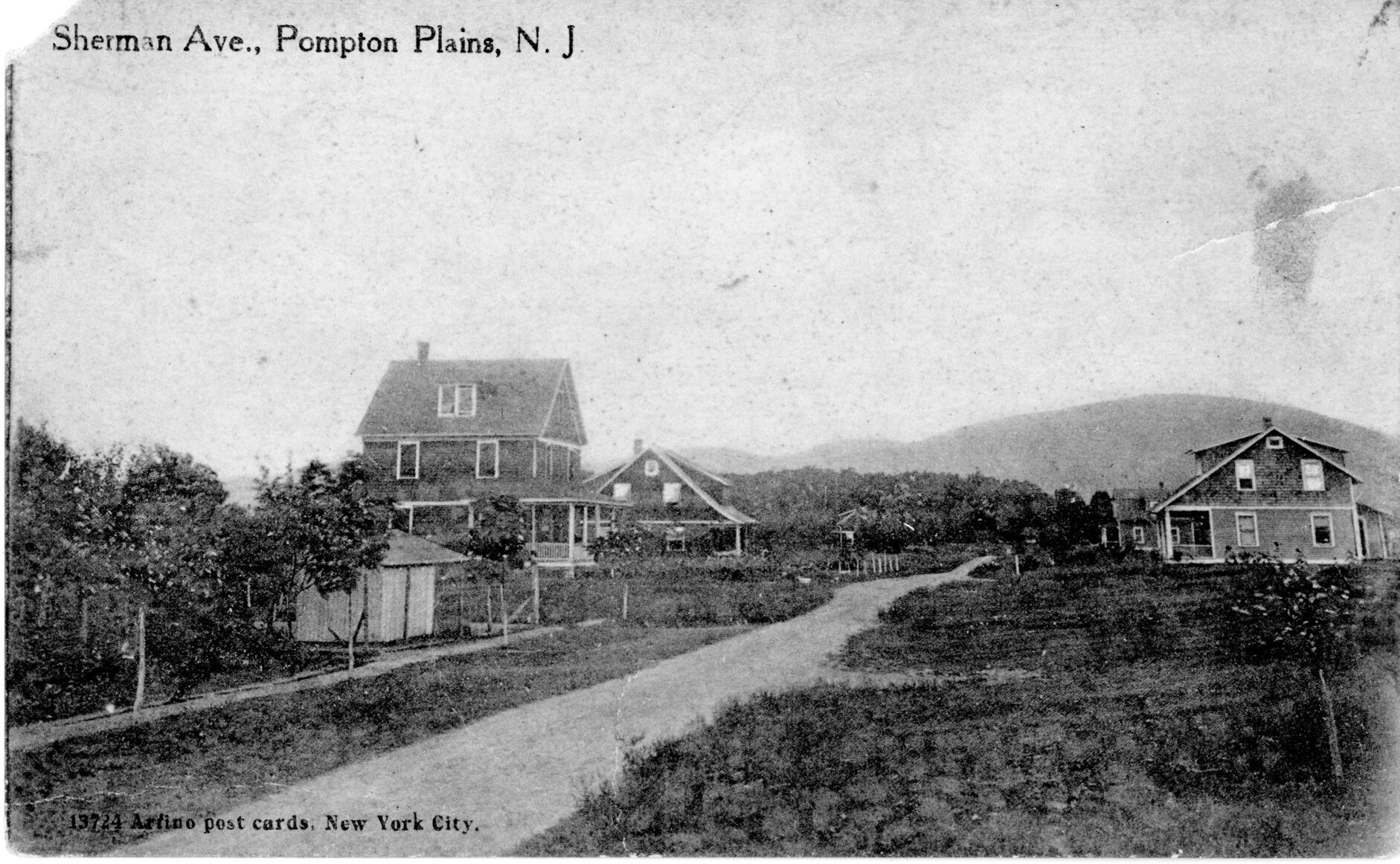
Ever wonder how Sherman Avenue, off the Boulevard in Pompton Plains, got its name? It was one of several roads built during the township’s expansion that began in the 1870s thanks to the new railroad. This photo is from about 1915 when the street was fairly new, unpaved, and not yet cluttered with houses.
Sherman Avenue, about 1915
The street was named for a real estate agent, George W. Sherman, who created a subdivision about 1910 on both sides of Sherman and the south side of Hopper Ave. He billed himself as “the largest real estate dealer in North Jersey.”
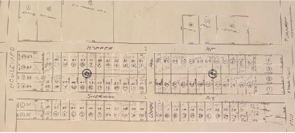
Portion of the 1915 tax map of Pequannock Township
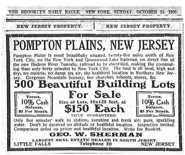
Then as now, there was plenty to like about Pompton Plains. A closer look at the ad, below, boasts that “The land is all level, high and dry; no malaria; no damp sea air; the healthiest location in North Jersey.” But wait, there was more: “Sunshine and fresh air [and] pure, sparkling water.”
A 1909 ad for Sherman’s building lots in Pompton Plains NJ
Buyers would also enjoy “Gorgeous Mountain Scenery, fine churches, schools, stores, etc.” and it was all “Only five minutes’ walk to the station”.
Anyone have photos of their homes on Sherman, or elsewhere in Pequannock Township, from back in the day? Leave a comment!
Thanks to Jay Wanczyk for contributing to this entry.
“Pompton Plains, New Jersey” is a famous painting by Jasper Francis Cropsey from about 1867.
Opinions differ on just where Mr. Cropsey placed himself while painting this wonderful view of the Pompton Valley. (Maybe if you could find that boulder…) You can see the Pompton River in the foreground; some speculate that the Morris Canal feeder dam lay just beyond the bend.
But if you look closely, right there in the center, is the First Reformed Church of Pompton Plains. (I’ve written about this church before.)
Do you see it? It’s way off in the distance. If you need a hint, here you go. (You can also click on the image above to see it vastly enlarged.)
We modern folk need to keep in mind that, in the 19th Century, the Pompton Valley was pretty empty. There were few buildings, and vast portions weren’t covered by trees as is the case today.
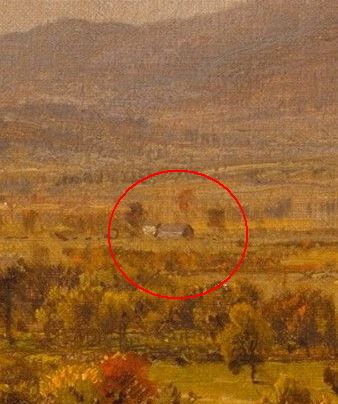
Other buildings in Cropsey’s painting may be identified. For example, this one – to the right of the church – appears to show the Martin Berry House and a barn in front of it. Look for the gap between the mountains in the full-sized image.
Since we know where the church is, it may be possible to identify some of the buildings on either side from other sources.
“Pompton Plains, New Jersey” may be seen at the Metropolitan Museum of Art.
Little remains of it today, but the “Pompton feeder” was an integral part of the Morris Canal system’s eternal need for water. The feeder was used to supply additional water to the Morris Canal by channeling water from the Pompton River. The feeder was, in fact, a navigable mini-canal that ran nearly five miles south from Schuyler’s Basin, at the river, to Mead’s Basin (known as Mountain View today). There was also a lock that afforded access to canal boats to the Ramapo River to head north.
The entire route looked like this. Click on it to view it full size.
Map of the Pompton feeder canal (credit: Joe Macasek)
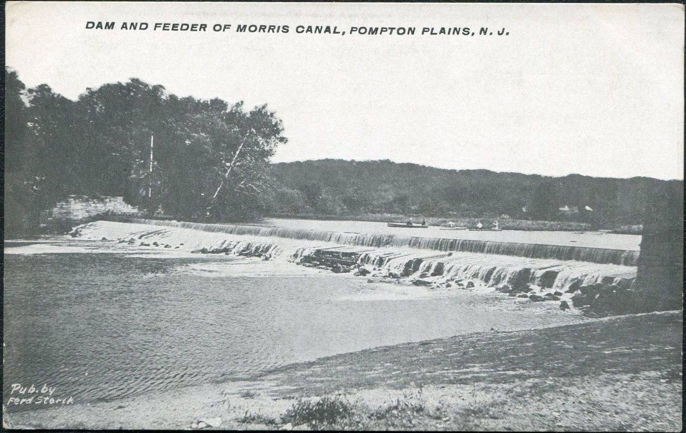
A wide, low dam was built on the Pompton River in Pompton Plains, NJ in 1837, six years after the Morris Canal was completed. This supplied a feeder lock which could, at the lock tender’s discretion, release water into the feeder canal.
Photo taken circa 1906 shows the wide, low feeder dam on the Pompton River.
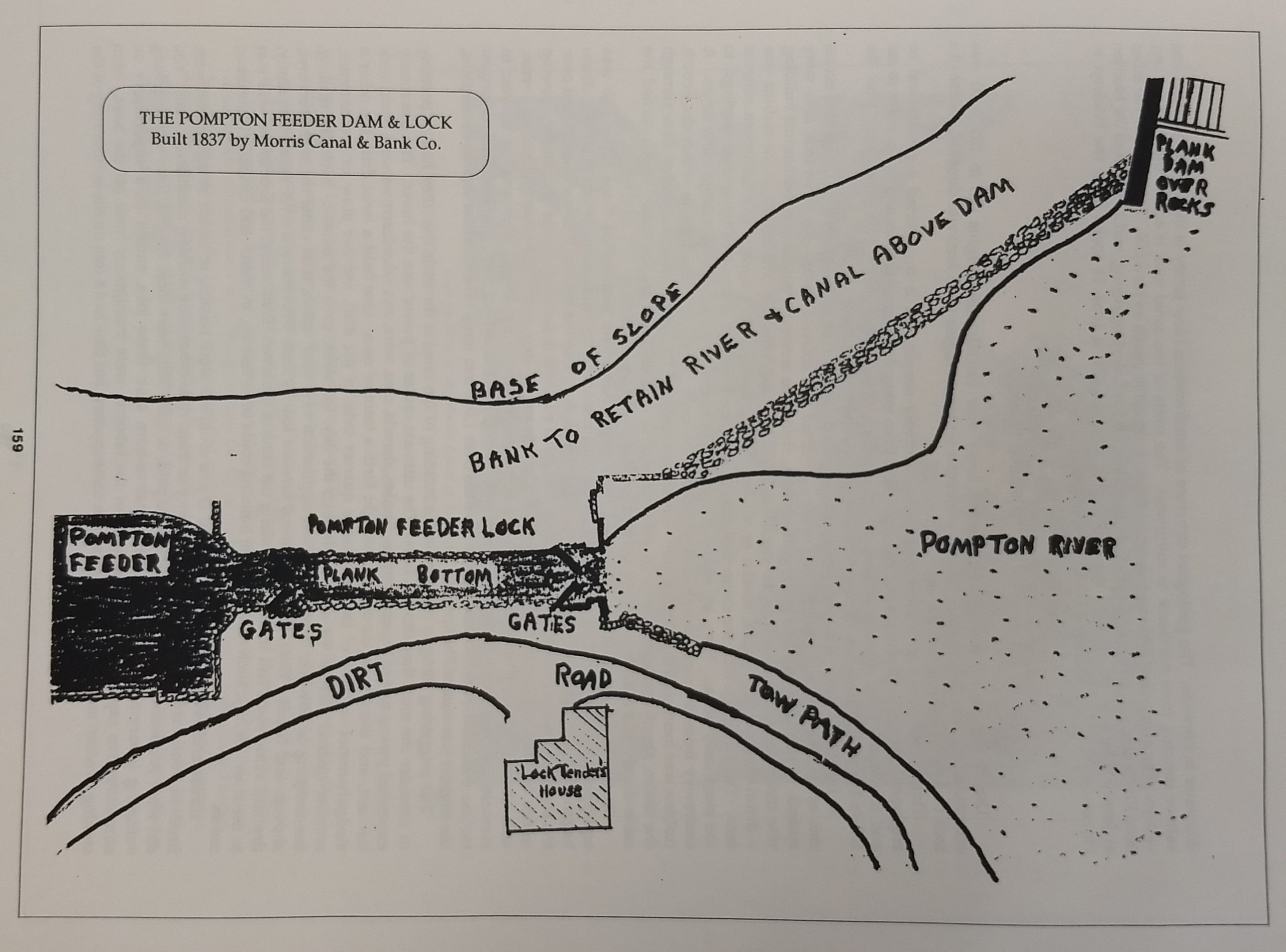
This diagram shows the setup: the river supplies water to the feeder canal via a lock. A lock tender lived in a house on site to release water as needed.
From “History of Pequannock Township” (1990) by George Parr, p. 159
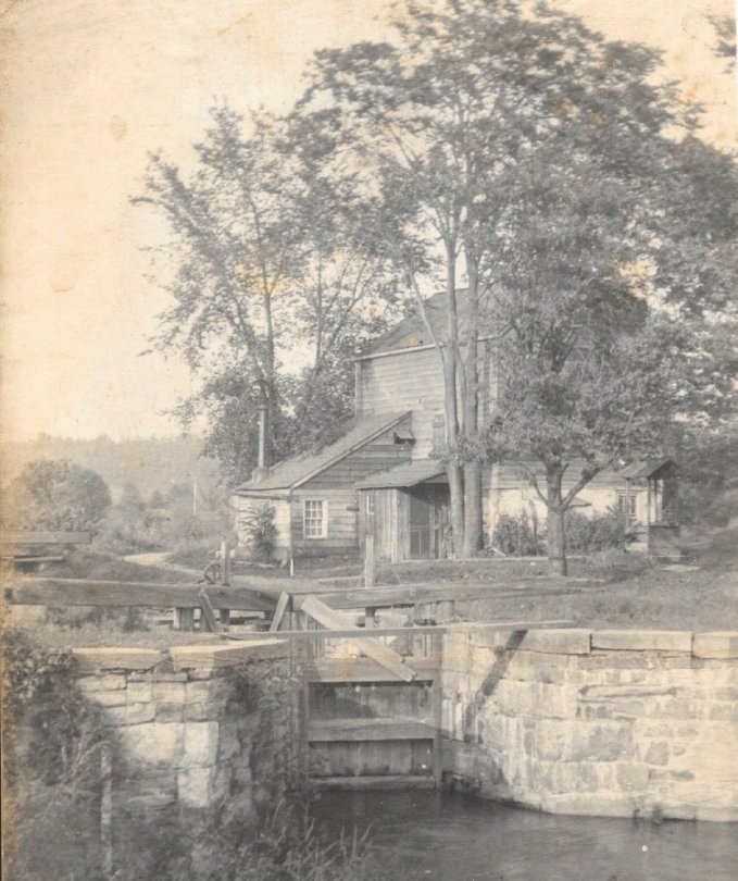
This early 20th Century photo shows the lock tender’s house and the lock.
The lock tender was always on call.
The Pompton feeder canal primarily served as an artery of the Morris Canal. The feeder lock — which was just upstream of the feeder dam — not only helped to maintain the feeder canal’s water level. It also admitted canal boats which traveled up from Mead’s Basin (Mountain View), through the lock, and into the Ramapo River, carrying coal and other supplies north to the Pompton Furnace area in Pompton Lakes. The boats would carry iron (and on occasion other) products back down to Mead’s Basin.
According to historian Ed Lenik, “The Pompton Feeder was a significant waterway: it provided water from Greenwood Lake to the Morris Canal’s eastern division. Pig iron, bar iron, wood, and other products were shipped south and coal, building products, food, and other merchandise were shipped north.”
The feeder canal also provided splendid recreation year ’round — fishing and swimming and canoeing in warm weather, and ice skating in the winter.
Canoeing was a popular pastime on the feeder canal. The bridge in the distance allowed foot and horse traffic to cross the feeder.
The feeder canal more or less paralleled the Pompton River. This photo, taken near the Newark-Pompton Turnpike in Pequannock near the Wayne border, shows the river (left) and the feeder canal side by side. The canal still exists as a muddy ditch. The bridge carries the Newark Watershed pipeline over the river and on to the cities which it serves.
The Morris Canal was successful for about a century before succumbing to the faster and more efficient railroad system. It was decommissioned about 1924, and large sections of it were drained and used for other purposes. Only a small part of the feeder canal itself remains in lower Pequannock; the lock lies in ruins, and the lock tender’s house was razed long ago. What remains is the feeder dam and spillway, which are part of the Morris Canal Greenway initiative, which is “envisioned as a 111-mile continuous pedestrian and bicycle trail connecting six counties in northern New Jersey.” Many segments of the greenway have already been completed, and a trail map is available as a guide to them.
As anyone who has lived in or near the Pequannock valley knows, we get floods from time to time. The convergence of three rivers makes it inevitable whenever there is prolonged and copious rain. I’ll write a post on several infamous floods at some point, but this post is about a flood that took place in April 1927, and a young mother, camping out in a riverside bungalow in Pompton Plains, who rescued her family from one.
I can’t match the breathless writing of this newspaper article, so I’ll just post it. Click on each image for a full-sized and readable version. I’ve added my comments afterward.
Part One of this incredible tale. Click to open full-sized image.
Pretty incredible, right? Imagine you’re in the middle of nowhere (Pequannock Twp was a lightly-populated village at this point), sleeping soundly in what was probably a one-room bungalow right on the river. You are awakened by odd sounds, you swing your legs off the bed and… into knee-deep water.
Since the article only calls her “Mrs. Ormsbee”, I took to the Ancestry website and discovered that her name was AliceShe was born Alice Miller in Beacon NY in 1900. She was 24 at the time this happened. With her was her mother (age unknown, but likely in her 40s) and her two young children, a son aged two and four-month-old daughter.
Part Two of this incredible tale. Click to open full-sized image.
So: It’s the middle of the night, it’s raining , your cabin is flooding, and it’s pitch black outside because the power is out. She leads her mother and two very young kids through the darkness to the bridge, hoping to get to the main road, only to find herself falling into the river because half the bridge is gone. She grabs a canoe and gets her family into it, and they all endure a night of terror until they’re rescued in the morning.
(The article notes she was “embarrassed by their clothing” likely because they were in their night clothes, and didn’t stop to get dressed.)
But what an incredibly brave young woman, at a time when women were widely regarded as kind of helpless, and weren’t expected to do or know much. Her two-year-old son, Roland, because a doctor and died in 1995. I don’t know when or where Alice passed, but I’ve reached out to someone who has her in his family tree. Perhaps I’ll learn more.
Pequannock residents still fondly recall a German restaurant known as the Triangle Hofbrau. In its last incarnation, it stood on Route 23 in Pequannock at the corner of Madison Street. It was an authentically high-class German restaurant, specializing in sauerbraten, roast Long Island Duckling, leg of lamb, reh schnitzel (venison steak), and a variety of seafood.
Triangle Hofbrau’s holiday dinner menu. Literally everything from soup to nuts.
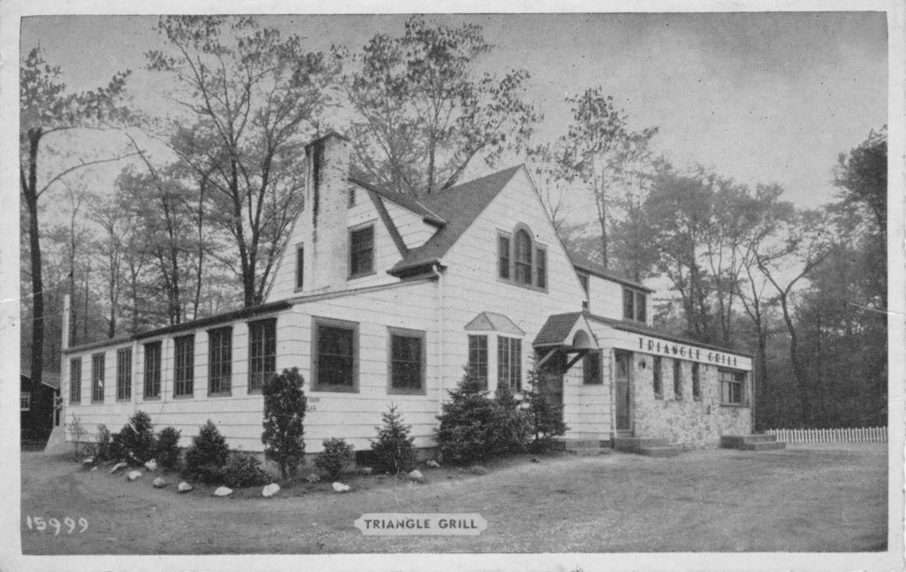
The original Hans’ Triangle Grill, a humble hot dog stand, was opened about 1932 on the Newark-Pompton Turnpike, on a literal triangle of land that intersects Lincoln Park Road. (In later years the location would be home to The Point, Rumsellers, and other establishments. Now, it’s a bank.) It was owned and run by Hans and Hilda Gropp, who had immigrated years before.
In 1933, when NJ began building Route 23, Hans and Hilda purchased land on the southbound side and moved the Triangle Grill there. The grand opening on July 30, 1936 was an immediate success, due in part to the traffic passing by. In those days, the highway’s north- and south-bound lanes were separated by a grass median. Conveniently, an opening in the median permitted north-bound cars to pull right into the parking lot.
At first, the Triangle Grill didn’t have a bar.
Inside, the tap room and dining rooms were finished in knotty pine to resemble an Alpine hunting lodge. A varied selection of choice wines and liquors joined the menu. At some point soon after, the Gropps renamed it the Triangle Hofbrau, and expanded their menu, making it a full-fledged — and authentically German — restaurant.
Over the decades, various changes and additions were made. I believe this was how it looked in the 1930s. The original house (with living quarters upstairs) is still recognizable. At the far right was the original walk-up window for hot dogs and such. The parking lot is unpaved, too.
When the Triangle Grill re-opened on Route 23, there was a walk-up window — you can see the steps at the far right — but an indoor seating area made it obsolete.At some point, the Dutch Colonial roof line was replaced with a standard peaked roof.
The Hofbrau served the area for many decades. The Gropps retired; other owners took over. According to W. Jay Wanczyk, head of the Pequannock Historic District Commission, ownership only changed hands three times in all of its history.
But in late 2007, the Triangle Hofbrau closed its doors for the last time. The place was sold to new owners, and Tiff’s Rivaaz now serves delicious food in its stead.
This is how I remember the Hofbrau; I passed it a zillion times, as I grew up on Madison Street. Compare with the earlier photos.
Several additions were made to the Hofbrau, including the huge dining room at left.
Dr. Charles D. Van Romondt (1847-1926) — typically referred to as “C.D.V. Romondt” — was described as a man “whose reputation is wide-spread”, and as “a leader in all plans which tended toward the elevation of the community with which he has been connected for so many years.”
Dr. Romondt’s residence was on Schelling Terrace, just off the Turnpike, and was razed in 2018.
Born in 1847 in New Brunswick NJ, he attended public school there. He was admitted into the College of Physicians and Surgeons at Columbia University in New York City, and graduated in 1872. He practiced medicine there for a few years before deciding to move to Pompton Plains in 1878. According to Emily Slingerland, quoted in a 1964 newspaper article, Dr. Romondt was the first doctor to live in the township. Before that, those seeking medical treatment needed to travel to Bloomfield.
Besides his medical practice, Romondt served as the township’s health inspector, as well as the medical inspector for the schools there. He also found time to be employed as a medical examiner for several insurance companies.
In 1890 he married Anna Doremus ( 1856–1955 ), who assisted her husband during his long medical practice in Pompton Plains.
The doctor was a member of several civic organizations, including the Junior Order of United American Mechanics. This group met at Paul Revere Hall, which isn’t surprising given the Jr. O. U. A. M. built it. You can view the cornerstone — today, the building is known as the American Legion Hall.
He died in 1926 and is buried at the Reformed Church in Pompton Plains.
October 24, 1937 was a bleak day for Pequannock Township. In a matter of hours, the First Dutch Reformed Church, first constructed in 1771, was entirely gutted by an early-morning fire. It took the combined efforts of 70 firemen from six other communities, in addition to Pequannock, to bring it under control.
There’s some fascinating video footage of the fire here, filmed by resident and local historian Carl Edwards. If you watch closely, the camera sometimes pans around to show the surrounding area.
It took the congregation less than a year and a half to completely rebuild the church from “ashes to splendor.” There’s video of the rebuilding process at this link, again courtesy of Mr. Edwards. The church is still in use today, known as the First Reformed Church of Pompton Plains.
Newspaper article about the 1881 robbery of William Jones’ store
Exchanging Shots with Burglars
Paterson, Aug. 10. – Word has just been received here of an encounter with the Storms gang of burglars at Pompton Plains on Sunday night. …
A year ago they robbed the store of Mr. William Jones, at Pompton Plains. On Sunday night last, sometime between midnight and 2 A.M., Mr. Jones heard a noise in the house. Going into the basement, he heard footsteps in the store. He immediately went up stairs, got his revolver, and went outside, where he found that a window shutter had been removed.
Peering in, he could see a man rummaging among the goods, and immediately fired at him. The burglar gave a shriek of pain. The light inside was extinguished and four shots were fired at Mr. Jones and his wife, who had followed him.
As they were standing in the bright moonlight, they retreated, and the robbers decamped. Mr. Jones recognized the man he shot as Jake Storms. He is thought to be wounded.
(Click on the image for a full-sized version.)
No idea where William Jones’ store was, or for that matter, who he was. I asked Rob Jones, but he didn’t recognize the name as part of his family tree. His grandfather took over an existing hardware store in April 1929, but that’s all I know, except that at one point, the place was a general store (and likely a post office) run by the Berry family.
I haven’t had any luck, so far, tracing the elusive Jake Storms further in history. Did he survive? Did his gang return to burgle again? Wouldn’t I like to know.
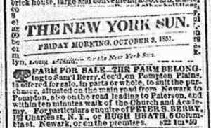
FARM FOR SALE – The farm belonging to Sam’l Berry, dec’d, on Pompton Plains, is offered for sale, in parts or whole, to suit the purchaser, situated on the main road from Newark to Pompton, also on the road leading to Paterson, and within ten minutes walk of the Church and Academy. For particulars enquire of PETER S. BERRY 157 Charles st, N.Y. or HUGH HEATH, 6 Columbia st Newark, or on the premises.
The “main road from Newark to Pompton” was, in fact, the Newark-Pompton Turnpike. “Within ten minutes walk of the Church and the [Union] Academy” tells us it wasn’t far from the First Reformed Church of Pompton Plains. That’s all I know; perhaps some Berry descendant can add more in the Comments.
Your typical “greetings from” postcard shows a generic illustration of fields, a country road, a lake, or whatever. This one, at least, does appear to have been taken in Pequannock. It shows a lovely view of the river… with Newark’s four-foot water pipeline crossing it.
Postcard sent in 1922
An idyllic scene, ostensibly from Pompton Plains. It’s probably a generic card, as witness the blocky font with the town’s name. “Greetings from YOUR TOWN HERE”.